
Project
HELIOS – GRID+ Project selected under the Open Call ESA BIC Lazio, Selection Campaign Q4 2025, incubated in the ESA Business Incubation Centre Lazio programme – CUP F87H26000200004
Project carried out with the financial support – PR Lazio ERDF 2021-2027 – Specific Objective 1.3. – Open Call ESA BIC Lazio – CUP F87H26000200004

HELIOS is a project developed by GRID+ within the ESA BIC Lazio programme, aimed at creating an advanced artificial intelligence solution applied to Earth Observation. The system is designed to generate, reconstruct and predict satellite multispectral data even in the presence of incomplete, discontinuous or temporally sparse observations, overcoming some of the typical limitations of EO data caused, for example, by cloud cover, satellite revisit frequency or the lack of useful acquisitions within certain time intervals.
The objective of the project is to increase the informational continuity and operational value of satellite data, transforming fragmentary observational series into more stable, interpretable information that can be used in real-world application contexts. HELIOS was conceived as a multispectral prediction and reconstruction engine, capable of supporting monitoring, analysis and validation activities in fields where the availability of continuous data represents a critical factor. The project’s first area of application concerns water monitoring and, more generally, environmental monitoring. From this perspective, the solution can be used to improve the temporal reading of phenomena observed by satellite, support the analysis of water bodies, basins, lakes, rivers and other environmental components, and contribute to the development of high operational value use cases. In parallel, the technology has also been designed for possible integration into existing Earth Observation platforms, geospatial services and technical workflows already in use within public or private organisations.
The objective of the project is to increase the informational continuity and operational value of satellite data, transforming fragmentary observational series into more stable, interpretable information that can be used in real-world application contexts. HELIOS was conceived as a multispectral prediction and reconstruction engine, capable of supporting monitoring, analysis and validation activities in fields where the availability of continuous data represents a critical factor. The project’s first area of application concerns water monitoring and, more generally, environmental monitoring. From this perspective, the solution can be used to improve the temporal reading of phenomena observed by satellite, support the analysis of water bodies, basins, lakes, rivers and other environmental components, and contribute to the development of high operational value use cases. In parallel, the technology has also been designed for possible integration into existing Earth Observation platforms, geospatial services and technical workflows already in use within public or private organisations.
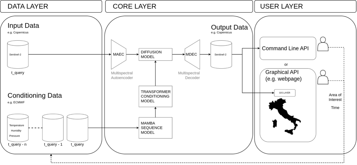
Figure 1. HELIOS: physics-conditioned latent diffusion for multispectral prediction.
From a technical standpoint, HELIOS combines generative models, components for time series processing and physical-climatic conditioning mechanisms, with the aim of producing coherent and scientifically usable multispectral outputs. The project is therefore not limited to theoretical experimentation, but aims at the progressive validation of an operational prototype and its evolution towards an integrable, scalable solution relevant to the market.
